


randonnée 1 phil

Ahimsa
User
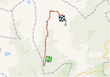

Length
9.8 km

Max alt
2403 m

Uphill gradient
1152 m
Km-Effort
23 km

Min alt
1241 m

Downhill gradient
376 m
Boucle
No
Creation date :
2025-05-25 06:26:49.217
Updated on :
2025-05-25 06:26:50.582
1h00
Difficulty : Very easy

FREE GPS app for hiking
 SityTrail
IGN / Geographical institutes
SityTrail Plus
The world is yours!
About
Trail Walking of 9.8 km to be discovered at Trentino-Alto Adige/Südtirol, Provincia di Trento, Castello Tesino. This trail is proposed by Ahimsa.
Positioning
Country:
Italy
Region :
Trentino-Alto Adige/Südtirol
Department/Province :
Provincia di Trento
Municipality :
Castello Tesino
Location:
Unknown
Start:(Dec)
Start:(UTM)
702651 ; 5111017 (32T) N.
Comments